Sypes Canyon Trail
Hiking distance: 4 miles round trip
Hiking time: 2 hours
Elevation gain: 1,000 feet
Maps: U.S.G.S. Bozeman and Kelly Creek, U.S.F.S.
Gallatin National Forest West Half or East Half
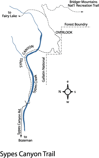
Summary of hike: Sypes Canyon follows a creekfed canyon on the west side of the Bridger Mountains. The hike leads through a lush, shady forest and up the south canyon wall. The hike ends at an overlook with outstanding views of the Gallatin Valley, Bozeman and the Madison and Tobacco Root Mountain Ranges.
Driving directions: From I–90 and the 7th Avenue overpass, drive 2 miles north on 7th Avenue, which becomes West Frontage Road, to Springhill Road. Turn right and drive 1.5 miles to Sypes Canyon Road. Turn right and continue 3.2 miles to Churn Road. Turn right and go 50 yards to the signed trailhead at the end of the road.
Hiking directions: Head east past the trail sign and through a grassy, fenced access. Enter a lush forest canopy into Sypes Canyon on the right side of Sypes Creek. Cross over to the north side of the creek, and head up the north wall of the canyon above Sypes Creek. At a half mile, the trail reaches a ridge. Descend alongside a rock wall cliff into the lush, forested canyon. Curve right at one mile, heading south up the canyon while skirting the edge of the national forest boundary. Begin an ascent through the shade of a lodgepole pine forest to a saddle by a trail sign with a view of the valley. Bear left 200 yards to a vista overlook of Bozeman and the Madison Range. This is a great spot to relax and enjoy the views before returning back down Sypes Canyon. To hike further, the trail continues to climb to a junction with the Bridger Mountains National Recreation Trail.