Sacagawea Peak
Hiking distance: 4 miles round trip
Hiking time: 3 hours
Elevation gain: 2,000 feet
Maps: U.S.G.S. Sacagawea Peak, U.S.F.S. Gallatin
National Forest East Half
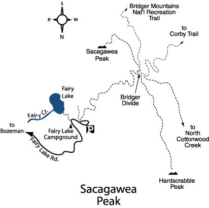
Summary of hike: Sacagawea Peak, at 9,665 feet, is the highest peak in the Bridger Range, part of the Gallatin National Forest. The trail climbs up Sacagawea Mountain to a saddle between Sacagawea Peak and Hardscrabble Peak at the Bridger Divide. From the divide the trail winds up to the rocky summit for fantastic views of mountain ranges in every direction. To the south are the Gallatin and Madison Ranges; the Big Belts lie to the north; the Elkhorns and Tobacco Roots lie to the west; and the Crazies are to the east.
Driving directions: From Main Street in downtown Bozeman, head north on North Rouse Avenue, and drive 21.4 miles to the signed Fairy Lake turnoff on the left. En route, the road curves right and becomes Bridger Canyon Drive (Highway 86). The turnoff is 0.9 miles past the Battle Ridge Campground. Turn left on Fairy Lake Road. Drive 6.1 miles on the unpaved road to the Fairy Lake Campground. Turn right and park 0.1 mile ahead at the signed trail on the left.
Hiking directions: From the signed trail, take the right fork through the conifer forest. Traverse the hillside up several switchbacks while great views open up to the east. Cross the northern edge of a meadow abundant with wildflowers. Switchbacks lead up the exposed rocky bowl at the head of the drainage. Climb up to the ridge on the Bridger Divide at 8,963 feet. At the divide are cairns and a signed junction. The right fork leads up to Hardscrabble Peak. Take the left fork and follow the ridge south. Pass a signed junction on the right, heading down the mountain to Corby Creek and North Cottonwood Creek. Continue gaining elevation southeast along the ridge. Bear left at a junction with the Bridger National Recreation Trail, and head north for the fir the peak. After enjoying the incredible views at the summit, return along the same path.