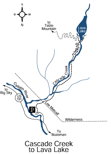
Cascade Creek to Lava Lake
Hiking distance: 6 miles round trip
Hiking time: 3.5 hours
Elevation gain: 1,600 feet
Maps: U.S.G.S. Garnet Mountain and Hidden Lake,
Rocky Mountain Surveys, Spanish Peaks Crystal Bench Maps—Bozeman,
Montana
Summary of hike: The hike to Lava Lake is a steep, uphill trail through a narrow, forested canyon of pine, spruce and fir trees. The 40–acre forest–lined lake sits in a small valley surrounded by granite walls with the Spanish Peaks rising in the distance. The lake was formed by a landslide that dammed Cascade Creek. It is the only lake in the Lee Metcalf Wilderness that was not glacially formed. The trail parallels the scenic, cascading whitewater of Cascade Creek.
Driving directions: From Four Corners 9 miles west of Bozeman, take Highway 191 south towards the Gallatin Canyon. Drive 20.3 miles to the Lava Lake Trailhead parking area on the right. The turnoff is located just north of the Gallatin River bridge. Turn right and continue 0.2 miles to the parking area.
From Big Sky, the Lava Lake trailhead parking area is 13.5 miles north on Highway 191. From this direction, you can not turn left to access the trailhead parking area. Drive past to the first turnout.
Hiking directions: From the parking area, the well?marked trail heads south past the trailhead sign into the forest, immediately gaining elevation. At 0.3 miles, the trail meets Cascade Creek. The trail continues up the canyon parallel to the creek and crosses a tributary stream. At 2 miles, the trail crosses a log footbridge to the east side of Cascade Creek. The last mile is steep. The trail gains altitude with a series of switchbacks arriving at the north end of Lava Lake.