Bear Trap Canyon Trail
Hiking distance: 0.5 to 14 miles round trip
Hiking time: 30 minutes and up
Elevation gain: 50 feet to 500 feet
Maps: U.S.G.S. Bear Trap Creek, Norris, Ennis
Lake, U.S.F.S. Gallatin National Forest, West Half, BLM Bear Trap Canyon
Wilderness Guide
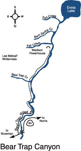
Summary of hike: The Bear Trap Canyon Trail, located in the Lee Metcalf Wilderness, hugs the eastern shore of the Madison River. This is a well known and popular trout fishing area. The trail winds through the 6,000?acre canyon along sheer rock cliffs carved 1,500 feet deep by the river. The only hiking access is from the north, insuring solitude the deeper into the canyon you hike. The full length of the trail is seven miles long. At the southern end is the dam and powerhouse holding back Ennis Lake. Hiking is prohibited around the dam.
Driving directions: From Bozeman, drive 9 miles west to Four Corners. Continue 20.7 miles west on Highway 84 to Bear Trap Road on the left. It is located by the Bear Trap Recreational Area sign, just before the bridge crossing the Madison River. Turn left and drive on the gravel road 3.2 miles along the east side of the river. The trailhead parking area is at the road's end.
Hiking directions: From the parking area, hike south along the east bank of the Madison River. The wide trail soon becomes a footpath and follows the eastern edge of the cliffs. At 3.5 miles Bear Trap Creek enters the Madison River from the east. There are also campsites here. You can turn around at any point, so hike as deep into the canyon as you choose. Follow the same path back.
Caution: Bear Trap Canyon has rattlesnakes. As a precaution, a snakebite kit is recommended.