
Hyalite Creek Trail to Hyalite Lake
Hiking distance: 11 miles round trip
Hiking time: 5 hours
Elevation gain: 2,000 feet
Maps: U.S.G.S. Fridley Peak, U.S.F.S. Hyalite
Drainage map, Crystal Bench Maps–Bozeman, Montana
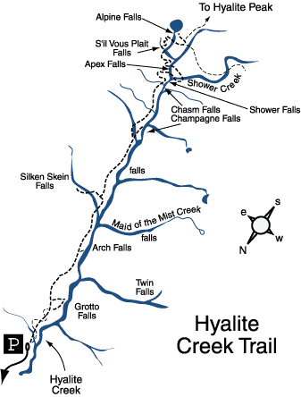
Summary of hike: The Hyalite Creek Trail is the premier hike in the entire Bozeman area. The trail passes eleven waterfalls in a deep canyon with massive cliff walls and majestic peaks. The hike ends at Hyalite Lake, a high mountain alpine lake in a horseshoe–shaped basin. The lake is surrounded by the craggy peaks of Fridley Peak and Hyalite Peak.
Driving directions: From Main Street and 19th Avenue in Bozeman, drive south on 19th Avenue, which becomes South 19th Road, 7 miles to Hyalite Canyon Road on the left?turn left. Continue 11.7 miles, crossing to the east side of Hyalite Reservoir, to a road fork. Take the right fork 1.9 miles to the Hyalite Creek/Grotto Falls parking area at the road's end.
Hiking directions: The Hyalite Creek Trail heads south on a wide path through the forest. The Grotto Falls Trail begins on the same path but zigzags through the forest, crossing the Hyalite Creek Trail four times. At the last junction, the left fork bypasses Grotto Falls and heads up the canyon. On the west canyon wall to the south of Elephant Mountain is Twin Falls, two waterfalls side by side plunging off the sheer cliffs. At 1.4 miles, a signed side path leads to Arch Falls on the right, a falls with a natural rock arch. At 2.2 miles, a signed detour to the left leads to Silken Skein Falls. A short distance ahead on the right is an unnamed 20-foot waterfall in a rock bowl with a pool. At 3 miles, a short detour leads to Champagne Falls, an 80-foot waterfall in a narrow fern-lined rock grotto. At 3.7 miles there are three successive waterfalls—Chasm, Shower and Apex. Cross a log footbridge over Hyalite Creek below the base of Apex Falls. Rock hop over Shower Creek, loop back and recross the creek at a stunning cascade. Cross to the east side of Hyalite Creek and pass S'il Vous Plait Falls. Recross the creek at the base of Alpine Falls and traverse the cliff overlooking the entire U-shaped canyon to a signed junction at 5.3 miles. Bear left to a second junction. The right fork leads to Hyalite Peak, 2 miles ahead. The left fork leads 100 yards to an overlook of Hyalite Lake at the base of Fridley Peak and Hyalite Peak. Descend to the shoreline in the dramatic mountain bowl. Return on the same trail. To see more pictures of Hyalite Creek Lake Trail, click here.
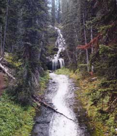
Apex Falls