 border="0"/>
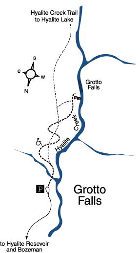
Grotto Falls
Hiking distance: 2.5 miles round trip
Hiking time: 1.25 hours
Elevation gain: 250 feet
Maps: U.S.G.S. Fridley Peak, U.S.F.S. Hyalite
Drainage map, Crystal Bench Maps–Bozeman, Montana
Summary of hike: Grotto Falls is a wide and magnificent waterfall. The forested trail to Grotto Falls is an easy wheelchair accessible gravel path. The surrounding mountains tower above the trail throughout the hike. Log benches have been placed at beautiful stopping points alongside Hyalite Creek. Grotto Falls is rated “difficult” as an accessible recreation trail. Outhouse located at the parking area.
Driving directions: From Main Street and 19th Avenue in Bozeman, drive south on 19th Avenue, which becomes South 19th Road, 7 miles to Hyalite Canyon Road on the left?turn left. Continue 11.7 miles, crossing to the east side of Hyalite Reservoir, to a road fork. Take the right fork 1.9 miles to the Hyalite Creek/Grotto Falls parking area at the road's end.
Hiking directions: From the parking area, hike south past the trailhead sign along the wide trail. A short distance ahead is a junction with the Hyalite Creek Trail. These two trails crisscross each other four times en route to the falls, and each junction is well marked. The Grotto Falls Trail is the wider trail and leads directly to the waterfall, where a log bench overlooks the falls. Return along the same trail. For a longer hike, continue on the Hyalite Creek Trail. It leads four miles further and 1,800 feet higher to Hyalite Lake and the Hyalite Basin. The trail passes ten stair-stepping waterfalls along the way.